Оригиналы файл(1174 × 1200 пикселы, файлы уæз: 55 КБ, MIME тип: image/png)

Описание

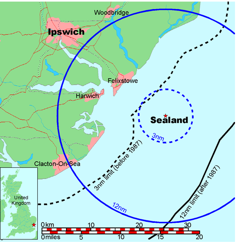
Map of Sealand

This is a map of the coast of England near Ipswich, showing the location of Sealand. The boundaries of the territorial water of the United Kingdom are also drawn, both the 3 nautical mile limit (5.556km) before 1987 and the 12nm limit (22.22km) after 1987. The same radii are also given around Sealand.

Note that these boundaries are derived based on the circular distance from the coastline, and not copied from official maps. This map is not suitable for navigation or for determining the boundaries of the UK territorial waters for legal or other purposes.

Создатель
Map generated by DEMIS World Map Server and edited by Chris 73
Бар
(Ацы файлæй ног архайд)


Licensing:

This image was created by Chris 73. The image is licensed under a dual license; please choose either of the two licenses below as desired. Attribution to Wikipedia or another project of the Wikimedia foundation is required for both licenses if the image is used outside of projects of the Wikimedia foundation. Attribution to me is not required.

GNU head Разрешается копировать, распространять и/или изменять этот документ в соответствии с условиями GNU Free Documentation License версии 1.3 или более поздней, опубликованной Фондом свободного программного обеспечения, без неизменяемых разделов, без текстов, помещаемых на первой и последней обложке. Копия лицензии включена в раздел, озаглавленный GNU Free Documentation License.

w:ru:Creative Commons
атрибуция распространение на тех же условиях
Этот файл доступен по лицензии Creative Commons Attribution-Share Alike 3.0 Unported.
Атрибуция: Chris 73 / Wikimedia Commons
Дæ бон у:
  • делиться произведением – копировать, распространять и передавать данное произведение
  • создавать производные – переделывать данное произведение
При соблюдении следующих условий:
  • атрибуция – Вы должны указать авторство, предоставить ссылку на лицензию и указать, внёс ли автор какие-либо изменения. Это можно сделать любым разумным способом, но не создавая впечатление, что лицензиат поддерживает вас или использование вами данного произведения.
  • распространение на тех же условиях – Если вы изменяете, преобразуете или создаёте иное произведение на основе данного, то обязаны использовать лицензию исходного произведения или лицензию, совместимую с исходной.

"I want to use the image. How do I do that?"

You can use this image freely for any purpose, including commercial use, provided that you license it under one of the above licenses. My suggestion is to use the following text:

This Wikipedia and Wikimedia Commons image is from the user Chris 73 and is freely available at //commons.wikimedia.org/wiki/File:Map_of_Sealand_with_territorial_waters.png under the creative commons cc-by-sa 3.0 license.

For privacy reasons please use only "Chris 73" as author. If necessary, please translate the text in your language. For electronic use please include the links in the text as shown, for printed use please print the text as shown. If you use the image I would appreciate it if you would let me know on my talk page, but this is not required as long as you follow one of the above licenses.


 Geotemporal data
Bounding box
N: 52.1374339°N
W: 0.9973602°E E: 1.6619722°E
S: 51.6274989°N
Georeferencing View the georeferenced map in the Wikimaps Warper

Краткие подписи

Добавьте однострочное описание того, что собой представляет этот файл

Элементы, изображённые на этом файле

изображённый объект уырыссаг

MIME-тип уырыссаг

image/png

845a9e08cbe7ed93bae6eeabe454399a76e3324f

метод определения уырыссаг: SHA-1 уырыссаг

размер данных уырыссаг

56 131 байт

высота/рост уырыссаг

1200 пиксель

ширина уырыссаг

1174 пиксель

Файлы истори

Ныххæц датæ/рæстæг-ыл, цæмæй фенай еуæд куыд фæзындис.

Датæ/рæстæгКъаддæргондБарæнтæАрхайæгФиппаинаг
нырыккон19:41, 9 июлы 2006Къаддæргонд уыцы версийæн: 19:41, 9 июлы 20061174 × 1200 (55 КБ)Chris 73update
10:00, 26 январы 2005Къаддæргонд уыцы версийæн: 10:00, 26 январы 20051024 × 1046 (50 КБ)Chris 73

Ацы файлæй пайда кæны иу фарс:

Ацы файлæй куыд пайда кæнынц

Данный файл используется в следующих вики: